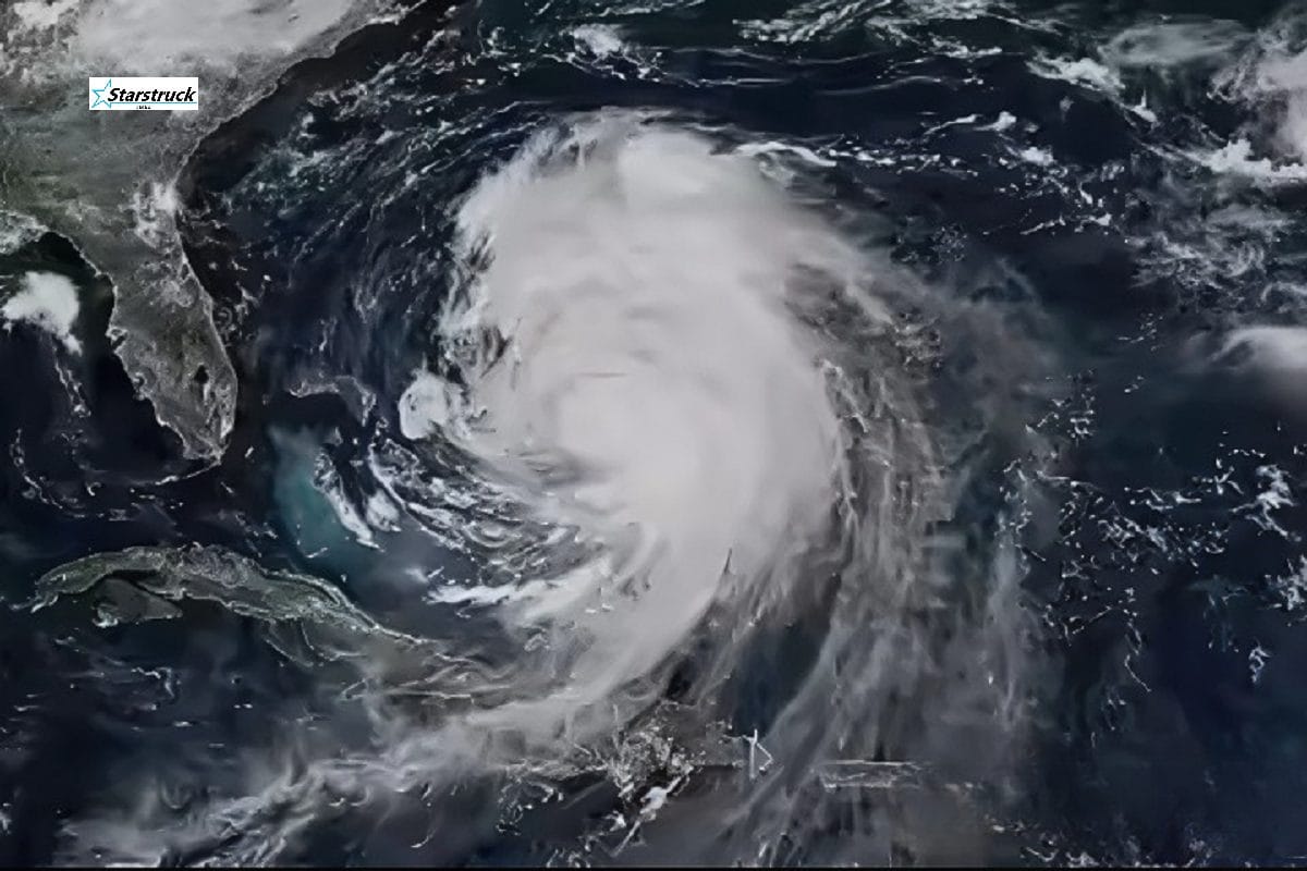
Satellite view of Hurricane Erin strengthening over the Atlantic
Hurricane Erin is strengthening over the Atlantic and moving toward the U.S. East Coast.
North Carolina’s Outer Banks and surrounding areas face the greatest risk of dangerous surf and rip currents.
Authorities have issued warnings for possible evacuations in vulnerable coastal zones.
Heavy rain, strong winds, and flash flooding could extend well inland if Erin’s path shifts.
Officials urge residents to prepare emergency kits, follow evacuation orders, and monitor official updates.
Hurricane Erin Threatens the East Coast: What You Need to Know
Hurricane Erin is steadily intensifying over the Atlantic Ocean, stirring anxiety along the U.S. East Coast. While the storm currently remains offshore, meteorologists warn that the system could unleash dangerous surf, rip currents, heavy rainfall, and potential evacuations across North Carolina and neighboring states in the coming days.
Officials from the National Hurricane Center (NHC) issued urgent advisories on Erin’s track and potential impacts. The storm, which developed into a Category 1 hurricane, is forecast to strengthen further as it churns closer to the coastline.
Residents across the Carolinas, Virginia, and Mid-Atlantic states are being urged to stay alert as officials monitor whether the storm could make a direct landfall or continue to parallel the coast, creating widespread coastal flooding and hazardous travel conditions.
Coastal Communities Brace for Impact
As Erin advances, North Carolina’s Outer Banks—a narrow chain of barrier islands especially vulnerable to storm surge—have become a primary concern. Officials warn that low-lying areas could face flooding even if the storm skirts offshore.
Governor’s offices across North Carolina and Virginia are in close coordination with FEMA and local emergency agencies. Evacuation routes are being prepared in case the storm veers closer to land.
“Even without a direct hit, Erin is capable of creating life-threatening surf conditions and dangerous rip currents,” an NHC spokesperson warned.
Hotels, businesses, and schools in vulnerable areas are considering closures, while supply runs for food, fuel, and bottled water have already begun in coastal towns.
Meteorologists Track Erin’s Strength
At the time of reporting, Erin is producing maximum sustained winds of 85 mph (140 km/h) with higher gusts. Forecast models suggest that the storm may intensify further into a Category 2 hurricane, depending on sea-surface temperatures and atmospheric conditions.
Meteorologists emphasize that the storm’s cone of uncertainty remains wide. A slight shift eastward could spare the mainland from the worst impacts, but a shift westward could bring direct landfall with devastating consequences.
Storm surge watches may be issued within 24–36 hours if Erin’s trajectory holds toward the coast.
Travel and Tourism Disruptions
The approach of Hurricane Erin has already led to cancellations of beach events, ferry services, and fishing charters along the Carolinas. Airlines have advised passengers traveling to or from Charlotte, Raleigh-Durham, and Norfolk to check for updates as potential flight disruptions loom.
The tourism-heavy Outer Banks region fears massive economic losses during what would normally be a peak season. Many vacationers are choosing to cut trips short rather than risk being stranded.
FAQs
1. Will Hurricane Erin make landfall in the U.S.? Meteorologists say it’s too early to determine. The storm could either parallel the East Coast or shift inland, but both scenarios carry risks of flooding and high surf.
2. Which areas are most at risk from Hurricane Erin? Currently, North Carolina’s Outer Banks face the greatest threat, but South Carolina, Virginia, and the Mid-Atlantic could also experience dangerous conditions.
3. What should residents do to prepare? Authorities recommend assembling emergency kits, securing outdoor items, monitoring evacuation alerts, and staying tuned to NHC advisories.
4. Could Erin strengthen further? Yes. Forecasts suggest Erin may intensify into a Category 2 hurricane before approaching the U.S. coastline.
Residents in North Carolina, Virginia, and surrounding areas: Are you prepared for Hurricane Erin? Share your thoughts in the comments below, and let us know if your community has started emergency preparations.
Stay tuned to Star Struck Times for real-time hurricane updates, safety tips, and official announcements.
Hello! I'm M Muzamil Shami, the founder and lead editor of Star Struck Times, your trusted source for trending news, entertainment scoops, celebrity gossip, sports highlights, and global headlines.
With a passion for storytelling and journalism, I created this platform to bring you breaking news, viral moments, and deep insights into the worlds of Bollywood, Hollywood, sports, politics, tech, and more — all in one place.