

Cleveland, United States, May 20, 2026 — Star Struck Times
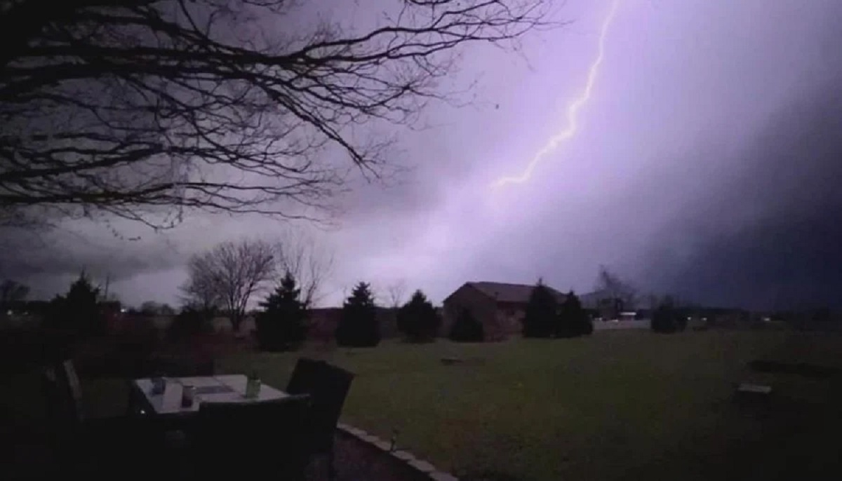
A high-stakes atmospheric battleground is unfolding over the Midwest as an aggressive polar cold front slams directly into an unprecedented, record-tying spring heatwave. The National Weather Service (NWS) has officially issued a comprehensive severe thunderstorm watch across key northern regions of the state, including Erie and Sandusky counties. This dangerous system comes directly on the heels of unseasonably stifling conditions that forced temperatures at Cleveland Hopkins International Airport to tie historic highs of $88^\circ\text{F}$ ($31^\circ\text{C}$), with suffocating humidity making the ambient air feel well into the $90\text{s}$. Local emergency management agencies are advising residents to secure outdoor property and monitor live radar feeds as the volatile front initiates its push across the region. Readers tracking breaking international crises can review our World News for real-time bulletins on concurrent global emergencies.
Key Atmospheric Highlights
- Active Severe Watches: The National Weather Service has placed Erie County, Sandusky County, and surrounding Northeast Ohio zones under strict severe thunderstorm watches due to extreme atmospheric instability.
- Historic Heat Spike: Cleveland tied its long-standing record high of $88^\circ\text{F}$ on Monday and Tuesday, providing the raw thermodynamic fuel necessary to supercharge incoming storm cells.
- Destructive Wind Hazards: Regional meteorologists warn that localized microbursts and systemic straight-line winds could easily exceed 35 to 50 mph, threatening local electrical grids and mature tree canopies.
- The Radical Plunge: A dramatic cold front trailing the storm line will trigger an immediate, jarring temperature drop, driving values down from midnight highs near $70^\circ\text{F}$ directly into the chilly mid-50s and low 40s by Wednesday afternoon.
The Perfect Storm: Unpacking Ohio’s Massive Temperature Inversion
The core mechanics driving this extreme weather event stem from a classic continental clash. Over the past 48 hours, a stubborn, high-pressure ridge pumped sub-tropical moisture up through the Mississippi Valley, trapping Northeast Ohio in an oppressive, mid-summer microclimate. According to data monitored by local meteorologists at WOIO and News 5 Cleveland, this extreme thermal buildup created an incredibly volatile atmosphere ahead of an encroaching Canadian trough.

When a low-pressure cold front moves into an environment characterized by such high surface temperatures and humidity, it acts as a massive wedge. The cold, dense air aggressively lifts the warm, moist air mass ahead of it, triggering explosive convective development. Forecasters note that the primary window for severe impact spans the late evening hours, with the most robust, structured storm cells consolidating between 5:00 PM and midnight.
What Other Reports Missed: The Multi-State Energy Grid Risk
While standard mainstream weather reports are focusing solely on the local timing of the rain, a deeper analytical look reveals a highly precarious situation for regional utility operators. The rapid shift from high air-conditioning demands during the afternoon peak of $88^\circ\text{F}$ to the sudden impact of localized, damaging straight-line winds presents a dual threat to the FirstEnergy transmission grid.
Furthermore, data from neighboring regions indicates that this exact same cold front has already disrupted municipal power infrastructures across portions of Oklahoma and Indiana earlier in its lifecycle. Because spring foliage is already fully bloomed across Northeast Ohio, even sub-tornadic wind gusts of 35 to 45 mph carry significantly higher risks of snapping heavy, leaf-laden branches onto residential power lines, meaning widespread rolling blackouts remain a distinct possibility overnight.
Official Safety Directives and Regional Responses
Public safety officials across the Miami Valley and the lakefront counties have quickly mobilized ahead of the primary squall line. The Ohio Emergency Management Agency has asked residents to double-check their emergency alert systems, warning that heavy rainfall rates could quickly cause flash flooding in poorly drained urban areas and low-lying rural underpasses.
“Our active weather pattern demands immediate situational awareness this evening,” stated a field update from Storm Center 7. “With a highly volatile boundary moving in from the west, these storms are packing a dangerous mix of localized flooding, frequent cloud-to-ground lightning, and the isolated potential for rotating cells. Move indoors immediately the moment you hear thunder.”
Local social media platforms have seen an explosion of activity as residents express shock over the sudden climate whiplash.
- “We went from turning on the central AC at lunchtime to pulling out the heavy winter blankets for tomorrow morning. This Midwest weather is completely unhinged,” commented a resident from Cleveland Heights on X.
- “The sky turned completely green out near Sandusky within twenty minutes. The wind is already starting to whistle through the valley,” shared another storm-spotter via Facebook.
The Hidden Context: A Fractured Memorial Day Weekend Forecast
Beyond the immediate tactical threats of tonight’s storm cells, this severe weather system marks the beginning of a broader, highly problematic macro-trend for the eastern half of the United States. While Thursday promises a brief, clear reprieval with crisp sunshine and comfortable highs in the lower 60s, long-range radar modeling reveals that a massive secondary trough is already organizing over the plains.
This subsequent system is projected to stall directly over the Midwest and Eastern Seaboard right as the long holiday weekend commences. For travelers and organizers planning outdoor events for the upcoming Memorial Day weekend, the lingering effects of this fractured pattern indicate widespread, recurring rain chances that will likely dampen holiday celebrations across multiple states.

What Happens Next
Meteorologists will spend the early morning hours of Wednesday assessing the structural damage, rainfall accumulations, and wind profiles left in the wake of the cold front. The high-velocity wind gusts behind the front will continue to buffet Northern Ohio through Wednesday afternoon, making high-profile driving hazardous on interstate routes. Temperatures will continue their steep downward trajectory throughout the day, bottoming out in the chilly 40s by late Wednesday night, requiring a complete recalibration of municipal heating and agricultural protection strategies across the state.
Frequently Asked Questions
What areas are currently affected by the Ohio severe thunderstorm watch?
The primary watch zones officially designated by the National Weather Service include Northern Ohio counties such as Erie and Sandusky, along with extended tracking areas stretching across Northeast Ohio and down toward portions of the Miami Valley.
Why is the temperature dropping so quickly in Cleveland?
The drastic drop is caused by the passage of a powerful Canadian cold front. After tying historic highs of $88^\circ\text{F}$ due to a warm tropical air mass, the following dense polar air mass is forcing temperatures down into the 50s and 40s within less than 24 hours.
Are tornadoes expected with this specific Ohio weather system?
While the primary threats remain straight-line damaging winds, frequent lightning, and torrential downpours, the extreme atmospheric instability and high wind shear along the leading edge of the cold front mean isolated, brief tornadoes cannot be entirely ruled out by forecasters.
How strong are the winds expected to get behind the cold front?
Even after the primary severe thunderstorm line departs, the post-frontal gradient is projected to generate persistent, strong westerly winds with gusts potentially reaching up to 35 to 50 mph through Wednesday afternoon.
How will this storm affect the upcoming Memorial Day weekend travel?
Though a brief window of calm, sunny weather will return on Thursday, a secondary large-scale rain system is forecasted to move back into the eastern United States by late Friday, threatening widespread wet conditions for the holiday weekend.
Sources
- National Weather Service (NWS): weather.gov
- WKYC 3News Cleveland Forecast Updates: wkyc.com
- Cox Media Group Storm Center 7 Tracking: whio.com


