

Toronto, Canada, May 20, 2026 — Star Struck Times
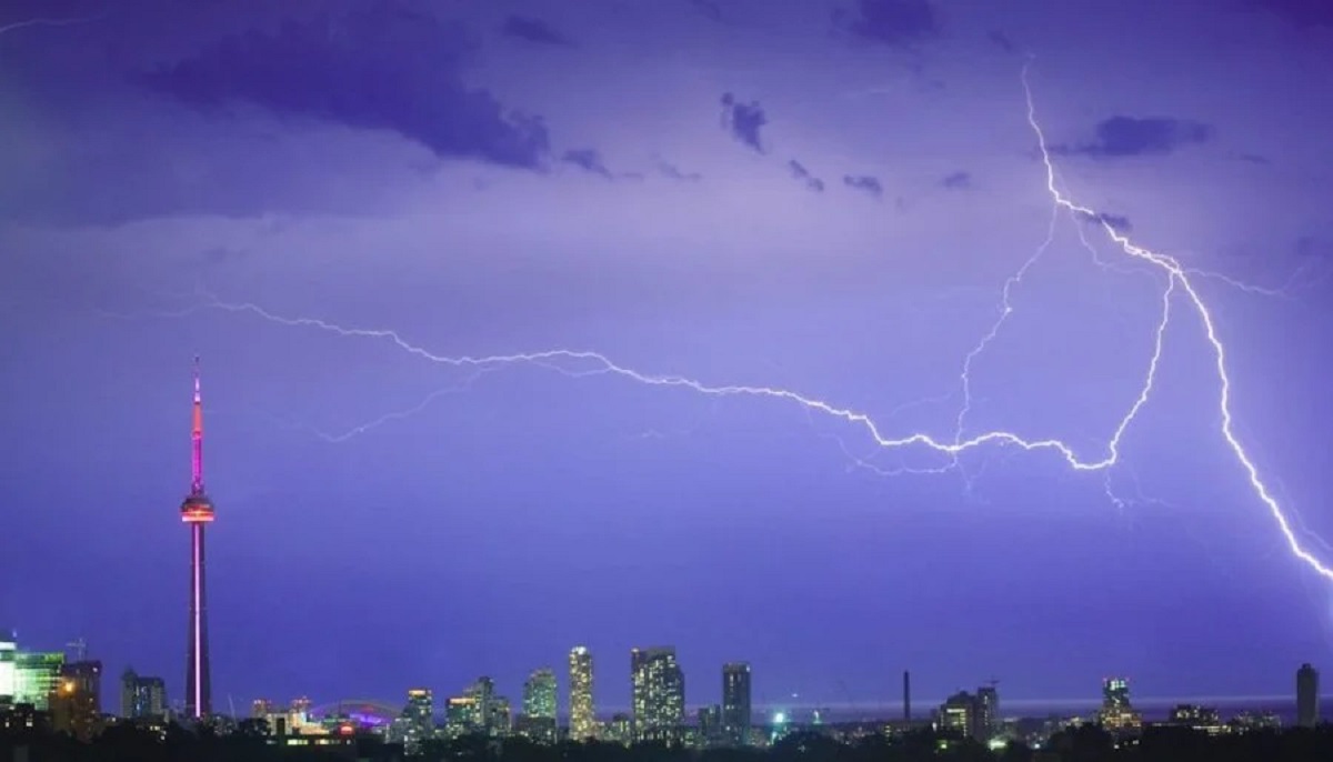
A volatile weather system is colliding with Southern Ontario’s first major summer heat spell. Environment and Climate Change Canada issued a severe thunderstorm watch for Toronto and the Greater Toronto Area (GTA). This yellow weather alert warns millions of residents of potentially damaging wind gusts, large hail, and localized structural destruction. The fast-moving system represents a sudden shift from extreme humidity to an impending cold front. It threatens to snap the region’s sweltering multi-day heatwave with severe atmospheric instability.
Key Highlights of the GTA Weather Alert
- Severe Storm Warning: Environment Canada warns of rapid thunderstorm development capable of generating 90 to 110 km/h wind gusts.
- Damaging Hail Risks: Forecasters note that conditions are ripe for quarter-sized hail, which can damage residential property, vehicles, and foliage.
- Extreme Heat Precursor: The storms follow a punishing heat wave where ambient temperatures hit 30°C, with a humidex making it feel like 36°C across the GTA.
- Imminent Temperature Drop: A trailing cold front will trigger a sharp temperature drop. Highs will plummet from 30°C down to 18°C within 24 hours, eventually hitting a low of 13°C by Saturday.
- Widespread Regional Alert: The severe weather watch extends past Toronto proper into York, Peel, Halton, and Hamilton regions.
The Atmospheric Clash: From 36°C Humidex to Damaging Winds
The Greater Toronto Area has spent the last 48 hours blanketed by a dense, humid air mass originating from the United States. This system pushed temperatures roughly 10 degrees above seasonal norms. According to Environment Canada meteorologist Kristina Kretchman, the sudden temperature surge felt particularly dramatic due to recent weeks of below-average spring temperatures.

By late Tuesday afternoon, Toronto reached a peak temperature of 30°C. Coupled with high humidity levels, the real-feel temperature spiked to 36°C. This forced municipal authorities to activate the city’s comprehensive Heat Relief Strategy, deploying mobile water trailers and opening air-conditioned cool spaces to protect vulnerable populations.
However, meteorologists warn that this extreme thermal energy is serving as fuel for a line of severe storms. A powerful cold front slicing through Ontario is encountering the sweltering, moisture-laden air mass. This setup creates high atmospheric instability, which causes rapid storm development.
“Damaging wind gusts will be the main threat with these storms,” caution officials from Environment Canada. “Local utility outages are possible. Damage to roofs, fences, branches or soft shelters is possible.”
Hidden Context: What Other Reports Missed
While mainstream outlets focus on the immediate storm timeline, local geographic data reveals a deeper story regarding Lake Ontario’s lake breeze effect. During early-season heat events, Lake Ontario remains chilly. This creates a sharp thermal boundary along the shoreline.
Historical data shows that these lake breeze fronts can act as a secondary trigger for severe weather. They can either tear down arriving storm cells or violently intensify them as they push inland over the high-altitude concrete architecture of the downtown core. For residents in our Weather News Section, understanding these localized urban microclimates is crucial. Communities further inland, including Brampton, Vaughan, and York Region, face a significantly higher risk of microburst winds and large hail than neighborhoods situated directly along the cooler lake shores.
Additionally, infrastructure analysts warn that the rapid transition from dry heat to sudden torrential downpours places severe pressure on municipal drainage. The city’s asphalt surfaces prevent water absorption. This raises the risk of flash flooding in lower-income basements and low-lying transit corridors like the Don Valley Parkway.
Public Reaction and Emergency Preparedness
Across social media platforms, GTA residents have expressed both relief over the ending of the heatwave and anxiety about potential power grid failures.
“The air feels heavy enough to cut with a knife right now in Mississauga,” shared local commuter David Vance on X. “We desperately need a cooldown, but nobody wants to lose power for days if these 110 km/h winds start knocking down old trees.”
Toronto Hydro and Alectra Utilities have reportedly placed emergency response crews on high alert to handle potential wire downs caused by snapped branches. Environment Canada urges residents to secure patio furniture, park vehicles under covered structures if possible, and stay indoors as the primary storm line approaches.

What Happens Next: The Impending Weekend Cooldown
The severe weather system acts as a hard reset for Ontario’s seasonal climate. As the storm line clears, the trailing cold front will push out the humid air mass completely.
The daytime high will drop to 18°C with clearer skies. The downward trend will continue through the week, with temperatures hitting a high of 16°C on Thursday and dropping further to 15°C on Friday. By Saturday, a wet weekend system will take over, bringing steady showers and a daytime high of just 13°C. This marks a massive 23-degree drop from the humidex peak seen earlier in the week.
Frequently Asked Questions
What areas are included in this severe thunderstorm watch?
The severe weather alert issued by Environment Canada covers the entire city of Toronto alongside the Greater Toronto Area (GTA), including York Region, Peel Region, Halton Region, and the City of Hamilton.
How strong will the wind gusts be during the storm?
Forecasters expect the primary threat to be damaging wind gusts reaching speeds between 90 km/h and 110 km/h. Winds of this velocity can damage roof shingles, fences, and weak structures, as well as cause localized power outages by snapping tree branches.
Will the Toronto heat warning continue after the thunderstorms?
No. The arrival of the cold front behind the thunderstorms will end the heat event. The sweltering 30°C daytime temperatures (feeling like 36°C) will drop immediately, falling to a high of 18°C and remaining cool through the upcoming weekend.
What should I do if quarter-sized hail begins to fall?
If large hail develops, take shelter indoors immediately. Keep away from windows, as hail can shatter glass. If you are driving, pull over safely under an overpass or gas station awning to protect your vehicle from structural dents and cracked windshields.
How can I find open cooling spaces or water stations in Toronto during a heat event?
Under the City of Toronto’s active Heat Relief Strategy, residents can access over 380 park water fountains, 247 park washrooms, 168 splash pads, and designated air-conditioned Cool Spaces at civic centers and local libraries.


