Thunderstorm clouds loom over Murree and upper Punjab as the Pakistan Meteorological Department issues new alerts for rain, wind, and hail in northern regions.
Strong winds, hail alerts as PMD issues fresh warnings across Kashmir, upper Punjab, KP
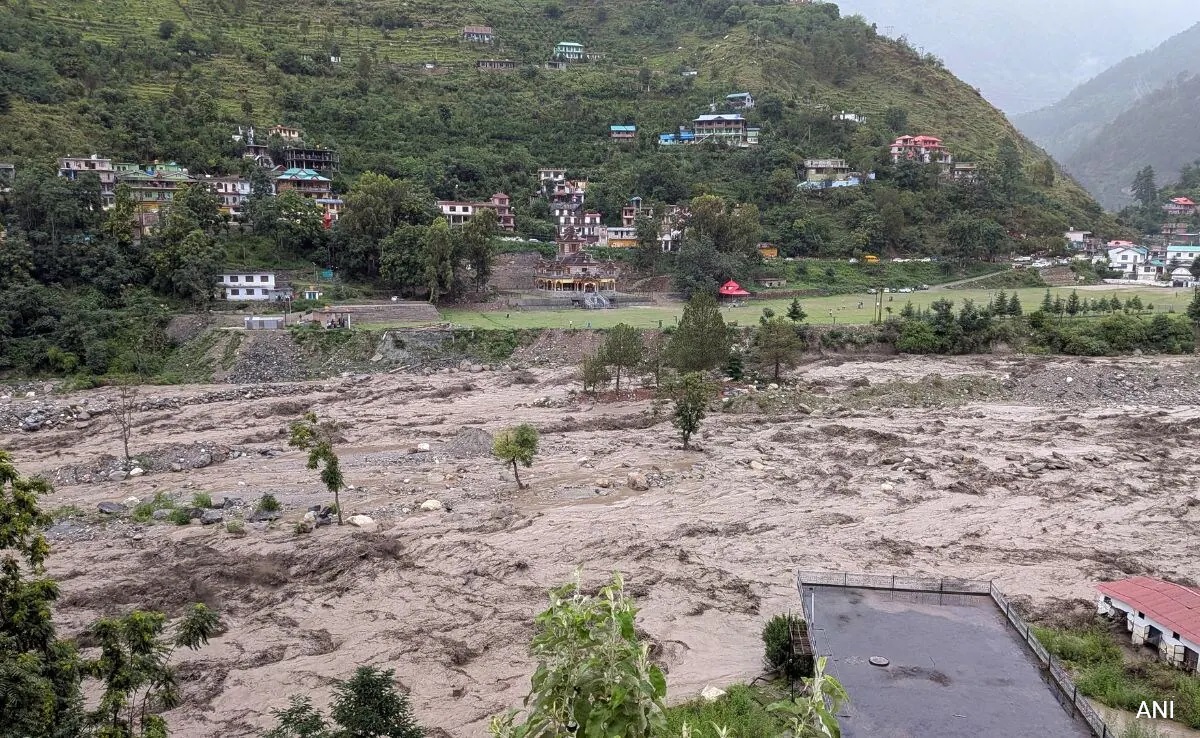
ISLAMABAD (Star Struck Times) — The Pakistan Meteorological Department (PMD) has issued a fresh storm alert for Kashmir, Islamabad, upper Punjab, and Khyber Pakhtunkhwa, predicting rain, windstorms, and thunderstorms over the next 24 to 48 hours, with isolated heavy downpours expected in vulnerable hilly and riverine zones. The warning comes at a critical moment when waterways are already swollen from earlier monsoon rains, raising the specter of flash floods and landslides in parts of the north.
According to PMD’s National Weather Forecasting Centre, moist air streams from the Bay of Bengal and Arabian Sea will push into upper Punjab while a Western Disturbance approaches from the west, intensifying instability in the atmosphere. Rain-wind and thunderstorm activity is likely in Islamabad, Rawalpindi, Attock, Murree, Chakwal, Jhelum, and Gujrat from tonight into the coming days, and may also extend to Kohisar, Galliyat, and adjoining hill tracts. In Khyber Pakhtunkhwa, districts including Dir, Swat, Chitral, Shangla, Mansehra, Abbottabad, and their surroundings are at risk of scattered heavy rain, lightning, and hail. Meanwhile, Kashmir and Gilgit-Baltistan may see isolated thunderstorm activity with chances of heavier falls in vulnerable valleys.
In recent 24-hour rainfall reports, Murree registered about 70 mm, while Rawalakot saw 68 mm, and parts of Rawalpindi and Islamabad recorded between 19 and 31 mm each. In Khyber Pakhtunkhwa, Kakul recorded 46 mm, Balakot 29 mm, and Pattan 14 mm. In the northern reaches of Gilgit-Baltistan, Astore recorded 3 mm, while Skardu and Bagrot logged 2 mm each.
Local residents in Murree and Galliyat said the skies darkened long before sunset. “Within minutes, wind gusts started lashing the trees and hailstones pounded our windows,” said one community member, speaking by phone. A tourist in Nathiagali lamented, “We had to abandon our route to Abbottabad after lightning struck nearby—it was terrifying.”
Authorities have expressed serious concern. Windstorms, hail, and lightning could damage weak structures, like kachcha houses, rooftop coverings, billboards, solar panels, and electric poles, PMD warned. Officials also cautioned that steep and vulnerable slopes in northern Khyber Pakhtunkhwa, Murree, Galliyat, and hilly tracts of Kashmir may experience landslides or rock falls due to saturated soils. Flash floods are another danger: nullahs and rain-fed streams in districts like Dir, Swat, Shangla, Buner, Kohistan, Abbottabad, Nowshera, Mardan, Murree, and adjacent areas could swell rapidly during bursts of intense rainfall. Travel on hilly and rural routes is also likely to be disrupted by poor visibility, waterlogging, and damage to road infrastructure.
PMD spokesman commented, “We urge people in vulnerable zones to remain alert, avoid unnecessary travel, and monitor our weather bulletins. Authorities in flood-prone districts should be on standby.” He added that snowfall is even possible at higher altitudes in Gilgit-Baltistan and upper reaches of Khyber Pakhtunkhwa, which may lower night-time temperatures further.
Public response has ranged from caution to concern. In social media feeds, citizens in Murree and Muradpur posted photos of downed tree branches, flooded roads, and damaged rooftops. Some expressed frustration over limited advance notice, while others praised timely PMD alerts. Local disaster authorities in Abbottabad and Mansehra said they have mobilized rescue teams and stationed equipment at vulnerable ridgelines.
This latest forecast builds on a broader trend of extreme weather in Pakistan this year. Earlier in August 2025, flash floods and landslides across Khyber Pakhtunkhwa claimed over 300 lives and destroyed infrastructure across dozens of districts. In Punjab, unprecedented floods submerged millions of acres and displaced thousands. The recent rains also follow severe hailstorms in April 2025 that battered Islamabad and Rawalpindi, damaging property and causing fatalities. Experts link these heightened extremes to climate change and warn Pakistan’s mountainous and riverine zones remain acutely exposed to cascading weather disasters.
As storm clouds gather once more, local governments are urged to pre-position relief resources, clear drainage channels, and disseminate early warnings. For residents, vigilance and preparedness are essential. Stay tuned to nwfc.pmd.gov.pk and local media for evolving updates, and avoid crossing rivers or nullahs when the rains intensify.
FAQs
Q: Where is storm activity most likely? A: The strongest storm risk is in Kashmir, upper Punjab (Murree, Galliyat), Islamabad/Rawalpindi, KP districts like Dir, Swat, Chitral, and high-altitude zones in Gilgit-Baltistan.
Q: What hazards should people expect? A: Flash floods, hail, lightning, strong winds, mudslides and damage to weak structures.
Q: When will the worst of it strike? A: The forecast period covers night through next 48 hours, especially late evening to early morning hours.
If you live in affected zones, prepare emergency kits, avoid travel during heavy bursts, and monitor real-time forecasts from PMD.
Hello! I'm M Muzamil Shami, the founder and lead editor of Star Struck Times, your trusted source for trending news, entertainment scoops, celebrity gossip, sports highlights, and global headlines.
With a passion for storytelling and journalism, I created this platform to bring you breaking news, viral moments, and deep insights into the worlds of Bollywood, Hollywood, sports, politics, tech, and more — all in one place.