

Boulevard, United States, May 20, 2026 — Star Struck Times
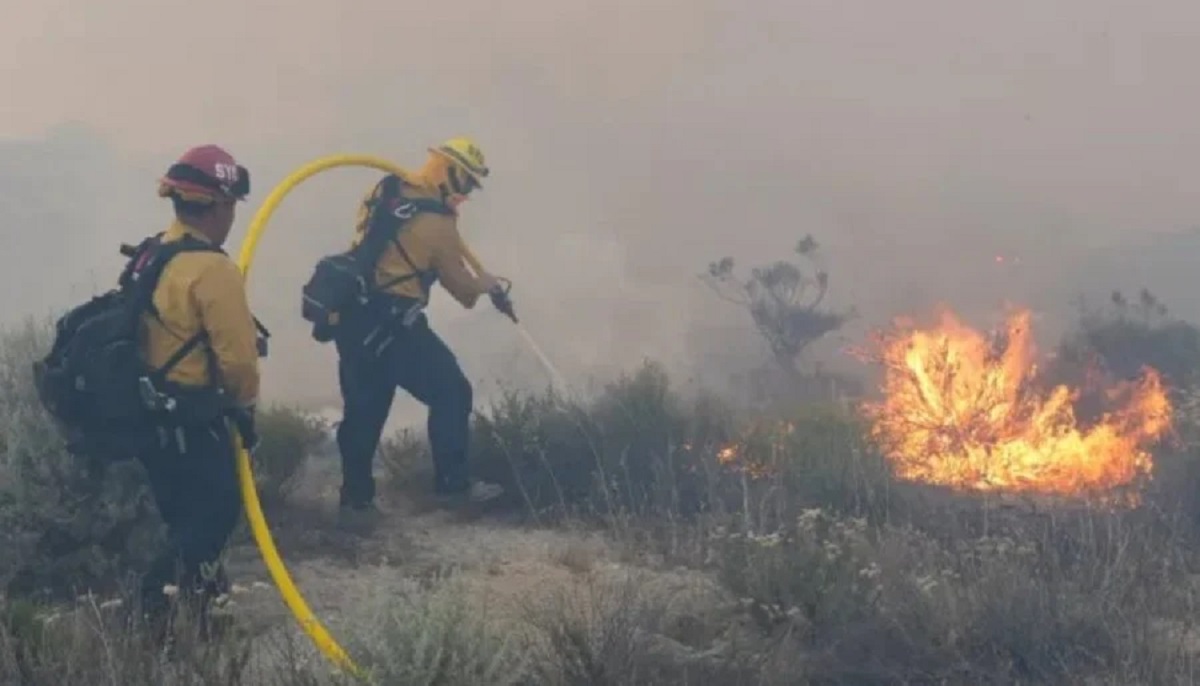
A fast-moving, highly aggressive brush fire has rapidly escalated in southeast San Diego County, prompting mandatory evacuation orders and shutting down a major interstate. The Tusil Fire, which erupted on Tuesday afternoon on the Campo Indian Reservation near the 37000 block of Tusil Road, has blackened more than 1,000 acres of light to moderate brush.
With containment hovering at a stark 10%, officials warn that erratic winds and active fire behavior continue to pose an immediate threat to residential and commercial structures. Local residents are urged to check their emergency zones immediately via the California Natural Disasters and Public Safety Directory category page for real-time safety updates.

Key Highlights of the Tusil Fire
- Current Acreage: The fire exploded from 10 acres to over 1,000 acres within a single day.
- Containment Status: CAL FIRE reports containment at just 10% as crews face challenging terrain.
- Major Highway Shutdown: Interstate 8 remains completely closed in both directions between Highway 94 and Buckman Springs Road.
- Emergency Shelter Open: An overnight evacuation shelter operated by the American Red Cross is active at the Golden Acorn Casino.
- Property Damage: Officials confirmed that at least one outbuilding and one vehicle have been destroyed, though no residential homes have been lost yet.
Escalation at the Campo Reservation: What Happened?
The blaze was first reported at approximately 1:00 PM on May 19, 2026, near Crestwood Road, Old Mine Road, and Williams Road. Driven by dry conditions and high winds, the flames tore through volatile brushlands at what CAL FIRE described as a “critical rate of spread.”
By mid-afternoon, the situation deteriorated drastically. The fire grew exponentially, jumping north across Interstate 8 by 5:30 PM. This unexpected spotting forced emergency personnel to halt all traffic along the crucial transportation corridor, stranding motorists and sending massive plumes of thick black smoke visible for miles across the county.
+-------------------------------------------------------------+
|               TUSIL FIRE CURRENT SITUATION                  |
+------------------------------+------------------------------+
| Metric                       | Status / Data                |
+------------------------------+------------------------------+
| Acres Burned                 | 1,000+ acres                 |
| Containment                  | 10%                          |
| Personnel Deployed           | 150+ Firefighters            |
| Primary Evacuation Center    | Golden Acorn Casino          |
| Livestock Shelter Location   | County South Shelter, Bonita |
+------------------------------+------------------------------+
Mandatory Evacuation Orders and Safe Zones
The San Diego County Sheriff’s Department has systematically updated its emergency map, transitioning several areas from precautionary warnings to immediate, mandatory Tusil Fire evacuation orders. An evacuation order represents an imminent threat to human life and serves as a lawful demand to leave the area immediately.
The legal enforcement zones under strict evacuation directives include:
- Evacuation Orders (Leave Now): Zones SDC-2170, SDC-2172, SDC-2240, and SDC-2324.
- Evacuation Warnings (Prepare to Leave): Zones SDC-2169, SDC-2171, SDC-2173, SDC-2325, and SDC-2326.
An overnight shelter has been set up at the Golden Acorn Casino (1800 Golden Acorn Way, Campo, CA). Small animals are being accepted outside the casino site via San Diego County Animal Services trailers. For residents with large livestock and horses, emergency intake is operational at the County South Shelter located at 5821 Sweetwater Road in Bonita.
What Other Reports Missed: The Microclimate Trap
While mainstream coverage focuses heavily on the sheer acreage of the burn, independent meteorological assessments reveal a highly localized threat. The Campo region sits within a unique high-desert boundary zone where afternoon winds funnel heavily through local mountain passes.
According to fire safety analysts, this wind funneling creates unpredictable thermal draft pockets. When the fire initially spotted across Interstate 8, it didn’t just cross asphalt—it entered a steep topographic alignment that naturally pulls wind upward, acting like a chimney. This explains the rapid multiplication of acreage from 550 to 1,000 acres in less than three hours, rendering traditional fire breaks momentarily ineffective.

“The forward rate of spread has challenged ground crews because the fire is effectively generating its own localized micro-drafts,” notes an expert-style insight from field coordinators. “Until air assets can successfully drop heavy retardant lines to box in the northern perimeter, structural protection remains the absolute priority.”
Public Reaction and Roadway Chaos
The closing of Interstate 8 has triggered significant travel delays throughout southeast San Diego and El Centro, causing severe frustration and anxiety for commuters trapped on surrounding rural corridors like Old Highway 80.
On social media, localized panic was palpable as residents watched the smoke columns expand.
“We could see the flames creeping down the ridge toward the highway from our porch,” shared Campo resident Maria Alvarez. “We didn’t wait for the official text alert; we packed up our dogs and headed straight to the casino.”
Another local driver, Ernest Garcia, posted online regarding the transit lockdown: “Trying to figure out how to safely get back to San Diego from El Centro right now. Old Highway 80 is completely backed up with emergency vehicles.”
What Happens Next
Over 150 firefighting personnel remain on the ground as dawn breaks over the San Diego Unit. Ground crews are working aggressively alongside air assets, utilizing water drops and bulldozer lines to establish strong containment boundaries north of the interstate.
The cause of the initial spark remains under active investigation by CAL FIRE investigators. Weather conditions over the next 24 hours will dictate whether containment percentages can safely climb, or if shifting wind vectors will force further evacuation orders for communities positioned deeper in the Boulevard and Lake Morena areas.
Frequently Asked Questions
1. Where can I find the official interactive map for the Tusil Fire evacuation orders?
You can view real-time boundary updates, zone changes, and road closures by visiting the official AlertSanDiego.org emergency map or by downloading the free Genasys Protect mobile application.
2. Is Interstate 8 open after the Campo fire?
No. Interstate 8 remains entirely closed to traffic in both directions between Highway 94 (westbound block) and Buckman Springs Road/Kitchen Creek Road (eastbound block). Motorists are instructed to avoid the area and use alternate regional routes.
3. Can I bring my pets to the Golden Acorn Casino evacuation shelter?
Yes. Small household pets are welcome at the Golden Acorn Casino temporary shelter. The County Animal Services has deployed specialized trailers and trucks directly outside the casino grounds to care for displaced domestic animals.
4. Where should large animals and livestock be evacuated?
Large animals, horses, and livestock cannot be accommodated at the casino. They must be safely transported to the San Diego County South Shelter, located at 5821 Sweetwater Road in Bonita, California.
5. What items should be included in an emergency go bag for California wildfires?
Your emergency go bag must contain non-perishable food, fresh water, necessary prescription medications, a change of extra clothing, critical financial/legal documents, a first aid kit, a flashlight, flash drives, and essential pet food.


