A renewed severe weather threat is developing across the central United States, with meteorologists warning that powerful thunderstorms, damaging winds, large hail, and isolated tornadoes could return across the Plains region by mid-to-late week. According to forecasts from the National Weather Service (NWS) and AccuWeather, the atmosphere is becoming increasingly unstable after a brief calm period, setting the stage for another active and potentially dangerous storm cycle.
This latest development comes as communities in North Dakota, Minnesota, Texas, and surrounding states prepare for rapidly changing conditions. The situation is being closely monitored due to overlapping risks of flooding, drought relief rainfall, and severe storm outbreaks.
Key Highlights
Severe thunderstorms expected across the U.S. Plains from Wednesday through Friday
Risks include hail, damaging winds up to 70 mph, and isolated tornadoes
Storm system will stretch from Texas to Minnesota before moving eastward
Some areas may face flooding, while drought-hit regions may benefit from rainfall
Meteorologists warn of “rapid storm development” due to Gulf moisture surge
Prior storm-affected regions may be hit again within days
What is Driving This Renewed Severe Weather Pattern?
The current forecast is being driven by a classic late-spring atmospheric setup across the central United States. A strong low-pressure system is expected to move eastward, interacting with warm, moisture-rich air flowing north from the Gulf of Mexico.
This collision of air masses is a well-known trigger for severe thunderstorms. The National Oceanic and Atmospheric Administration (NOAA) explains that when warm, humid air rapidly rises into cooler upper-level air, it creates unstable conditions capable of producing supercell thunderstorms.
According to AccuWeather meteorologist Peyton Simmers, “the primary threat will initially be hail, but localized damaging wind gusts up to 60 mph remain possible, especially in stronger storm cells.”
Storm Timeline: How the Week Will Unfold
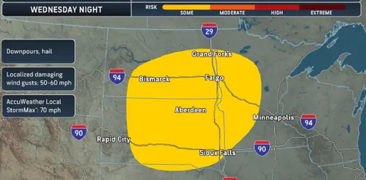
Midweek Development (Wednesday)
The first round of thunderstorms is expected to develop across North and South Dakota into western Minnesota. While initially scattered, these storms could intensify quickly overnight.
Major Outbreak Potential (Thursday–Friday)
A broader and more dangerous zone will open across Texas, Oklahoma, Kansas, Nebraska, and extending toward Minnesota. This phase carries the highest risk for severe weather, including:
Large hail capable of damaging vehicles and rooftops
Wind gusts reaching 60–70 mph
Isolated tornado formation in rotating storm cells
The storm system is expected to gradually push eastward into the Mississippi Valley and Gulf Coast states by Friday night.
Why This System Matters More Than a Typical Spring Storm
What makes this weather event particularly significant is its scale and repeated impact zones. Many of the regions now under threat were already affected by severe storms in the previous week, meaning the ground is saturated in some areas while infrastructure repairs are still ongoing.
Meteorologists note a growing pattern of “back-to-back storm cycles,” where storm systems return before recovery is complete. This increases risks for:
Power outages due to repeated wind damage
Transportation disruption across highways and rural routes
Agricultural stress in already drought-affected regions
Flash flooding in low-lying communities
In a statement referenced by the National Weather Service Storm Prediction Center, forecasters emphasized that “even short-duration storms can become dangerous when atmospheric instability peaks rapidly.”
Hidden Context: What Other Reports Missed
While most reports focus on immediate storm threats, a deeper climate pattern is also worth noting. The central U.S. is currently experiencing a transition between late winter atmospheric instability and early summer heat-driven storm development.
This transition often leads to:
Stronger temperature contrasts across regions
Increased moisture transport from the Gulf of Mexico
More frequent “reloading” storm systems within days
Experts suggest this could signal a more active-than-normal spring severe weather season, though long-term confirmation will require continued observation.
Regional Impact: From Relief Rain to Severe Threat
Interestingly, not all impacts of this system are negative. Portions of eastern Texas, Arkansas, and western Alabama are currently experiencing severe to extreme drought conditions, according to the U.S. Drought Monitor.
This storm system could provide much-needed rainfall relief. However, the benefit comes with risk, as heavy downpours may lead to localized flooding in urban and poorly drained areas.
This dual nature of the system—helpful rain versus destructive storms—makes forecasting and preparedness more complex than usual.
Expert Insight
Meteorology analysts highlight that this pattern is consistent with springtime “jet stream amplification,” where shifting upper-level winds increase storm intensity.
Dr. Alan Reeves, a climate systems analyst cited in recent NOAA briefings, notes: “Spring transitions are becoming more volatile in terms of storm clustering. We are seeing shorter recovery windows between major weather events.”
What Happens Next
The storm system will continue tracking eastward into the weekend. Weather models suggest additional instability could follow shortly after, meaning this may not be the last severe weather outbreak of the season.
Residents across the Plains and Midwest are advised to remain alert to updated forecasts and warnings from official meteorological agencies.
FAQs
1. Which areas are most at risk from these storms?
The highest risk zones include Texas, Oklahoma, Kansas, Nebraska, Minnesota, and parts of the Mississippi Valley.
2. What hazards are expected in this storm system?
The system may produce hail, damaging winds, heavy rainfall, flash flooding, and isolated tornadoes.
3. Why are storms becoming more frequent in the U.S. Plains?
Seasonal atmospheric shifts and moisture inflow from the Gulf of Mexico often trigger repeated storm cycles during spring.
4. Will these storms help drought conditions?
Some rainfall may provide relief, especially in Texas and Arkansas, but flooding remains a concern.
5. When will the storm system end?
The main system is expected to move east by the weekend, but additional storm activity may follow shortly after.
Hello! I'm M Muzamil Shami, the founder and lead editor of Star Struck Times, your trusted source for trending news, entertainment scoops, celebrity gossip, sports highlights, and global headlines.
With a passion for storytelling and journalism, I created this platform to bring you breaking news, viral moments, and deep insights into the worlds of Bollywood, Hollywood, sports, politics, tech, and more — all in one place.